
Make a donation
Gear up for your next adventure:
As an Amazon Associate, this site earns from qualifying purchases at no extra cost to you.
Nitrianske Pravno topographic map
Click on the map to display elevation.
Make a donation
Gear up for your next adventure:
As an Amazon Associate, this site earns from qualifying purchases at no extra cost to you.
Nitrianske Pravno
The municipality lies at an altitude of 348 metres (1142 feet) and covers an area of 31.195 km² (12.045 mi²). It has a population of about 3,180 people. The municipality lies in the upper Nitra River valley region, 12 km north of Prievidza.
Make a donation
Gear up for your next adventure:
As an Amazon Associate, this site earns from qualifying purchases at no extra cost to you.
About this map
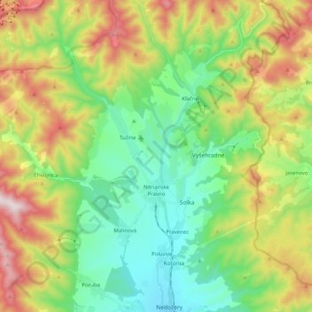
Name: Nitrianske Pravno topographic map, elevation, terrain.
Average elevation: 1,857 ft
Minimum elevation: 958 ft
Maximum elevation: 3,504 ft
Make a donation
Gear up for your next adventure:
As an Amazon Associate, this site earns from qualifying purchases at no extra cost to you.
Other topographic maps
Click on a map to view its topography, its elevation and its terrain.
Gápel
Slovakia > Region of Trenčín > District of Prievidza > Valaská Belá > Gápel
Average elevation: 2,139 ft
Prievidza
Slovakia > Region of Trenčín > District of Prievidza > Prievidza > Prievidza
Average elevation: 1,089 ft