Geolocate

Beaumont topographic map

Click on the map to display elevation.

About this map

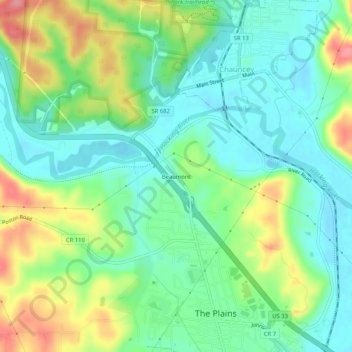
Name: Beaumont topographic map, elevation, terrain.

Location: Beaumont, Athens, Athens County, Ohio, 45780, United States (39.36563 -82.15820 39.40563 -82.11820)

Average elevation: 738 ft

Minimum elevation: 630 ft

Maximum elevation: 945 ft

Athens County trails, hiking, mountain biking, running and outdoor activities

Other topographic maps

Click on a map to view its topography, its elevation and its terrain.

Pratts Fork

United States > Ohio > Athens County > Athens

Average elevation: 833 ft

Gear up for your next adventure:

🧦Merino Wool Socks - Moisture-wicking, blister-preventing socks for long treks
🥩Freeze-Dried Meals - Nutritious and lightweight food for remote expeditions
🩳Quick‑Dry Hiking Shorts - Comfortable and quick‑dry shorts for summer hiking
🛡️Bear Spray Outdoor - Protection in bear country hikes
🚗GPS Dash Cams - Record your scenic drives through mountain passes and canyons

As an Amazon Associate, this site earns from qualifying purchases at no extra cost to you.