
Fairfield topographic map
Click on the map to display elevation.
About this map
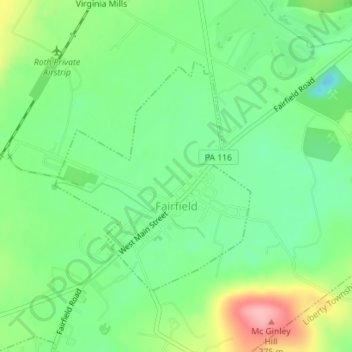
Name: Fairfield topographic map, elevation, terrain.
Location: Fairfield, Adams County, Pennsylvania, United States (39.78079 -77.38075 39.79837 -77.36119)
Average elevation: 623 ft
Minimum elevation: 466 ft
Maximum elevation: 902 ft
Adams County trails, hiking, mountain biking, running and outdoor activities
Other topographic maps
Click on a map to view its topography, its elevation and its terrain.
Raven Rock Mountain
United States > Pennsylvania > Adams County > Liberty Township
Average elevation: 1,024 ft
Gladhill (Greenstone P.O.)
United States > Pennsylvania > Adams County > Hamiltonban Township
Average elevation: 1,198 ft