Geolocate

Corinth topographic map

Click on the map to display elevation.

About this map

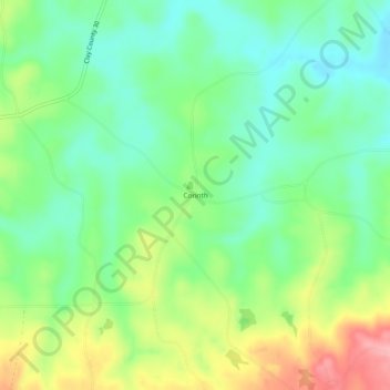
Name: Corinth topographic map, elevation, terrain.

Location: Corinth, Clay County, Alabama, 36255, United States (33.18540 -85.71163 33.22540 -85.67163)

Average elevation: 873 ft

Minimum elevation: 725 ft

Maximum elevation: 1,138 ft

Clay County trails, hiking, mountain biking, running and outdoor activities

Other topographic maps

Click on a map to view its topography, its elevation and its terrain.

Delta

United States > Alabama > Clay County

Average elevation: 997 ft

Talladega Mountain

United States > Alabama > Clay County

Average elevation: 1,109 ft

Gear up for your next adventure:

🎒Trekking Poles - Sturdy poles for balance and stability on rough terrain
⛑️Personal Locator Beacon - Safety beacon for emergencies
🧢Outdoor Hiking Hat - Sun protection hat for outdoor explorers
🖼️Topo Map Wall Art - Decorative topographic prints of famous peaks and regions
🔋Rechargeable Batteries - Power up your outdoor devices

As an Amazon Associate, this site earns from qualifying purchases at no extra cost to you.