
Make a donation
Gear up for your next adventure:
As an Amazon Associate, this site earns from qualifying purchases at no extra cost to you.
Beausse topographic map
Click on the map to display elevation.
Make a donation
Gear up for your next adventure:
As an Amazon Associate, this site earns from qualifying purchases at no extra cost to you.
Beausse
Son territoire se situe sur un plateau. L'altitude de la commune varie de 83 à 156 mètres, et sa superficie est de plus de 5 km2 (536 hectares).
Make a donation
Gear up for your next adventure:
As an Amazon Associate, this site earns from qualifying purchases at no extra cost to you.
About this map
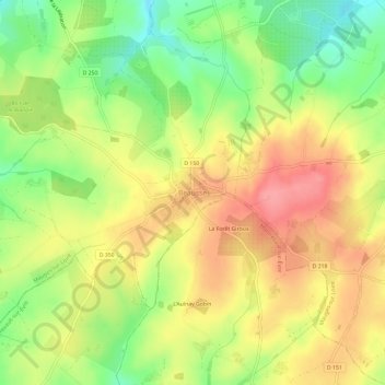
Name: Beausse topographic map, elevation, terrain.
Average elevation: 430 ft
Minimum elevation: 272 ft
Maximum elevation: 568 ft
Make a donation
Gear up for your next adventure:
As an Amazon Associate, this site earns from qualifying purchases at no extra cost to you.
Other topographic maps
Click on a map to view its topography, its elevation and its terrain.
Le Mesnil-en-Vallée
France > Pays de la Loire > Maine-et-Loire > Mauges-sur-Loire
Average elevation: 141 ft