
Make a donation
Gear up for your next adventure:
As an Amazon Associate, this site earns from qualifying purchases at no extra cost to you.
Hydro topographic map
Click on the map to display elevation.
Make a donation
Gear up for your next adventure:
As an Amazon Associate, this site earns from qualifying purchases at no extra cost to you.
Hydro
Hydro is located near the northwestern corner of Caddo County at an elevation of 1,557 feet (475 m). A small part of the town extends north into Blaine County.
Make a donation
Gear up for your next adventure:
As an Amazon Associate, this site earns from qualifying purchases at no extra cost to you.
About this map
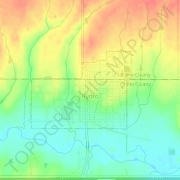
Name: Hydro topographic map, elevation, terrain.
Location: Hydro, Caddo County, Oklahoma, United States (35.54399 -98.58856 35.55564 -98.57007)
Average elevation: 1,545 ft
Minimum elevation: 1,467 ft
Maximum elevation: 1,631 ft
Make a donation
Gear up for your next adventure:
As an Amazon Associate, this site earns from qualifying purchases at no extra cost to you.