Geolocate

Chevril topographic map

Click on the map to display elevation.

About this map

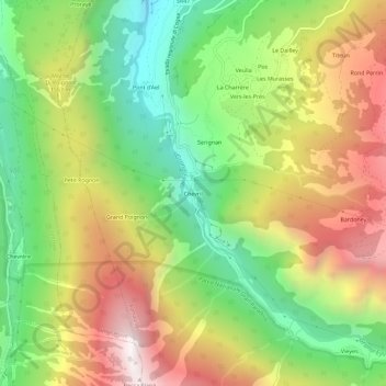
Name: Chevril topographic map, elevation, terrain.

Location: Chevril, Aymavilles, Aosta Valley, 11010, Italy (45.64617 7.20999 45.68617 7.24999)

Average elevation: 4,685 ft

Minimum elevation: 2,484 ft

Maximum elevation: 7,379 ft

Gear up for your next adventure:

Camping Coffee Makers - Enjoy premium coffee at the summit or campsite
🧭GPS Watch Accessories - Bands and chargers for GPS watches
GPS Sports Watch - GPS watch for running, hiking and training
🧤Hiking Gloves - Protective gloves for rugged trails
📚Navigation Handbooks - Master the art of reading topographic maps and using a compass

As an Amazon Associate, this site earns from qualifying purchases at no extra cost to you.