
Dreetz topographic map
Interactive map
Click on the map to display elevation.
About this map
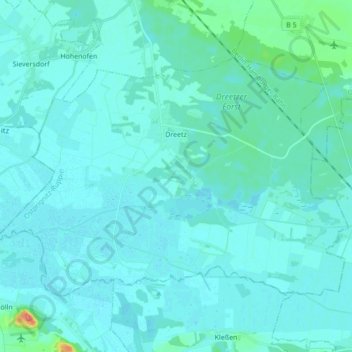
Name: Dreetz topographic map, elevation, terrain.
Average elevation: 102 ft
Minimum elevation: 79 ft
Maximum elevation: 325 ft
Other topographic maps
Click on a map to view its topography, its elevation and its terrain.
Noord-Europese Laagvlakte
Duitsland > Brandenburg > Ostprignitz-Ruppin > Lindow (Mark) > Banzendorf
De maximale hoogte bedraagt ongeveer 300 meter. Het gebied bestaat voor een deel uit landbouwgebied en is op veel plaatsen sterk verstedelijkt. Daarnaast kent het gebied veengebieden, heidevelden, bosgebieden en meren. Aan de Noordzeekust kan men moerasssen vinden en de Waddenzee; een groot getijdengebied.
Average elevation: 177 ft