
Thank you for supporting this site ❤️
Make a donation
Make a donation
Gear up for your next adventure:
As an Amazon Associate, this site earns from qualifying purchases at no extra cost to you.
Lorchhausen topographic map
Click on the map to display elevation.
Thank you for supporting this site ❤️
Make a donation
Make a donation
Gear up for your next adventure:
As an Amazon Associate, this site earns from qualifying purchases at no extra cost to you.
About this map
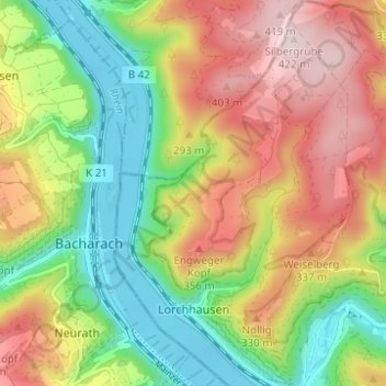
Name: Lorchhausen topographic map, elevation, terrain.
Location: Lorchhausen, Lorch, Rheingau-Taunus-Kreis, Hessen, Deutschland (50.04508 7.77247 50.08482 7.82156)
Average elevation: 771 ft
Minimum elevation: 233 ft
Maximum elevation: 1,411 ft
Thank you for supporting this site ❤️
Make a donation
Make a donation
Gear up for your next adventure:
As an Amazon Associate, this site earns from qualifying purchases at no extra cost to you.