Geolocate

Volga topographic map

Click on the map to display elevation.

About this map

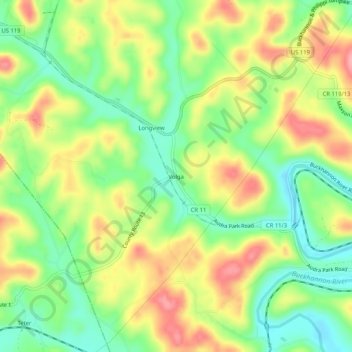
Name: Volga topographic map, elevation, terrain.

Location: Volga, Barbour County, West Virginia, 26238, United States (39.05843 -80.15536 39.09843 -80.11536)

Average elevation: 1,509 ft

Minimum elevation: 1,345 ft

Maximum elevation: 1,699 ft

Barbour County trails, hiking, mountain biking, running and outdoor activities

Other topographic maps

Click on a map to view its topography, its elevation and its terrain.

Junior

United States > West Virginia > Barbour County

Average elevation: 1,926 ft

Gear up for your next adventure:

🛡️Insect Repellent - Protection against bugs during outdoor activities
🪓Survival Multi‑Tool - Versatile tool for camp and trail tasks
🧼Biodegradable Camping Soap - Eco‑friendly soap for outdoor hygiene
🪶Survival Guide Book - Expert advice for emergency preparedness
🎁Geography Themed Gifts - Unique gift ideas for map lovers and geography enthusiasts

As an Amazon Associate, this site earns from qualifying purchases at no extra cost to you.