Geolocate

Leesville topographic map

Click on the map to display elevation.

About this map

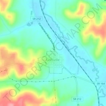
Name: Leesville topographic map, elevation, terrain.

Location: Leesville, Carroll County, Ohio, United States (40.44809 -81.21715 40.45891 -81.20323)

Average elevation: 1,014 ft

Minimum elevation: 909 ft

Maximum elevation: 1,237 ft

Carroll County trails, hiking, mountain biking, running and outdoor activities

Other topographic maps

Click on a map to view its topography, its elevation and its terrain.

Kilgore

United States > Ohio > Carroll County

Average elevation: 1,217 ft

Lake Mohawk

United States > Ohio > Carroll County

Average elevation: 1,093 ft

Gear up for your next adventure:

🧥Men's Rain Shells - Premium waterproof and breathable jackets for mountain weather
🛠️Outdoor Gear Repair Kit - Essential tools to fix gear on the trail
🧺Microfiber Travel Towels - Compact and fast-drying towels for trail use
🎒Trail Energy Bars - High‑calorie bars for hiking energy
🔋Rechargeable Batteries - Power up your outdoor devices

As an Amazon Associate, this site earns from qualifying purchases at no extra cost to you.