
Make a donation
Gear up for your next adventure:
As an Amazon Associate, this site earns from qualifying purchases at no extra cost to you.
Lagarde-Enval topographic map
Click on the map to display elevation.
Make a donation
Gear up for your next adventure:
As an Amazon Associate, this site earns from qualifying purchases at no extra cost to you.
About this map
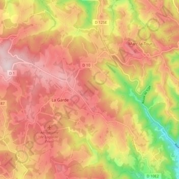
Name: Lagarde-Enval topographic map, elevation, terrain.
Average elevation: 1,467 ft
Minimum elevation: 807 ft
Maximum elevation: 1,867 ft
Make a donation
Gear up for your next adventure:
As an Amazon Associate, this site earns from qualifying purchases at no extra cost to you.
Other topographic maps
Click on a map to view its topography, its elevation and its terrain.
Le Bois de Breuil
France > Nouvelle-Aquitaine > Corrèze > Lagarde-Marc-la-Tour
Average elevation: 1,447 ft
Make a donation
Gear up for your next adventure:
As an Amazon Associate, this site earns from qualifying purchases at no extra cost to you.
La Chapeloune
France > Nouvelle-Aquitaine > Corrèze > Lagarde-Marc-la-Tour > La Méchaussie
Average elevation: 1,608 ft
La Méchaussie
France > Nouvelle-Aquitaine > Corrèze > Lagarde-Marc-la-Tour
Average elevation: 1,552 ft
Soulage
France > Nouvelle-Aquitaine > Corrèze > Lagarde-Marc-la-Tour > Soulage
Average elevation: 1,375 ft
Make a donation
Gear up for your next adventure:
As an Amazon Associate, this site earns from qualifying purchases at no extra cost to you.
Enval
France > Nouvelle-Aquitaine > Corrèze > Lagarde-Marc-la-Tour > Enval
Average elevation: 1,329 ft
La Borie Basse
France > Nouvelle-Aquitaine > Corrèze > Lagarde-Marc-la-Tour
Average elevation: 1,467 ft