
Grant Lake topographic map
Interactive map
Click on the map to display elevation.
About this map
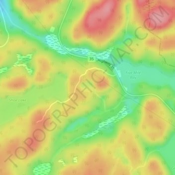
Name: Grant Lake topographic map, elevation, terrain.
Average elevation: 1,260 ft
Minimum elevation: 1,070 ft
Maximum elevation: 1,421 ft
Other topographic maps
Click on a map to view its topography, its elevation and its terrain.
Ril Lake
Canada > Ontario > Lake of Bays Township > Lake of Bays
Ril Lake, South Ril Lake Road, Lake of Bays Township, District Municipality of Muskoka, Muskoka District, Central Ontario, Ontario, Canada
Average elevation: 1,184 ft
Dickie Lake
Canada > Ontario > Lake of Bays
Dickie Lake, Dickie Lake Road, Lake of Bays, District Municipality of Muskoka, Muskoka District, Central Ontario, Ontario, Canada
Average elevation: 1,181 ft
Cream Lake
Canada > Ontario > Lake of Bays
Cream Lake, South Ril Lake Road, Lake of Bays, District Municipality of Muskoka, Muskoka District, Ontario, Canada
Average elevation: 1,191 ft
Menominee Lake
Canada > Ontario > Lake of Bays
Menominee Lake, Grand Boulevard, Lake of Bays, District Municipality of Muskoka, Muskoka District, Ontario, Canada
Average elevation: 1,165 ft
Dotty Lake
Canada > Ontario > Lake of Bays
Dotty Lake, Brookes Road, Lake of Bays, District Municipality of Muskoka, Muskoka District, Ontario, Canada
Average elevation: 1,322 ft
Porcupine Lake
Canada > Ontario > Lake of Bays
Porcupine Lake, South Ril Lake Road, Lake of Bays, District Municipality of Muskoka, Muskoka District, Ontario, Canada
Average elevation: 1,184 ft