
Make a donation
Gear up for your next adventure:
As an Amazon Associate, this site earns from qualifying purchases at no extra cost to you.
Valley-Hi topographic map
Click on the map to display elevation.
Make a donation
Gear up for your next adventure:
As an Amazon Associate, this site earns from qualifying purchases at no extra cost to you.
About this map
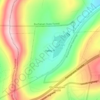
Name: Valley-Hi topographic map, elevation, terrain.
Location: Valley-Hi, Fulton County, Pennsylvania, United States (40.02168 -78.19915 40.03709 -78.18292)
Average elevation: 1,634 ft
Minimum elevation: 1,227 ft
Maximum elevation: 2,080 ft
Fulton County trails, hiking, mountain biking, running and outdoor activities
Make a donation
Gear up for your next adventure:
As an Amazon Associate, this site earns from qualifying purchases at no extra cost to you.
Other topographic maps
Click on a map to view its topography, its elevation and its terrain.
Wells Tannery
United States > Pennsylvania > Fulton County > Wells Township
Average elevation: 1,447 ft
Harrisonville
United States > Pennsylvania > Fulton County > Licking Creek Township
Average elevation: 915 ft
Make a donation
Gear up for your next adventure:
As an Amazon Associate, this site earns from qualifying purchases at no extra cost to you.
Fort Littleton
United States > Pennsylvania > Fulton County > Dublin Township
Average elevation: 945 ft
Crystal Spring
United States > Pennsylvania > Fulton County > Brush Creek Township
Average elevation: 1,375 ft
Big Cove Tannery
United States > Pennsylvania > Fulton County > Ayr Township
Average elevation: 909 ft
Make a donation
Gear up for your next adventure:
As an Amazon Associate, this site earns from qualifying purchases at no extra cost to you.