
Thank you for supporting this site ❤️
Make a donation
Make a donation
Gear up for your next adventure:
As an Amazon Associate, this site earns from qualifying purchases at no extra cost to you.
Mumias topographic map
Click on the map to display elevation.
Thank you for supporting this site ❤️
Make a donation
Make a donation
Gear up for your next adventure:
As an Amazon Associate, this site earns from qualifying purchases at no extra cost to you.
About this map
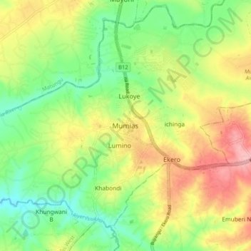
Name: Mumias topographic map, elevation, terrain.
Location: Mumias, Mumias Central ward, Mumias West, Kakamega County, Kenya (0.29611 34.44954 0.37611 34.52954)
Average elevation: 4,268 ft
Minimum elevation: 4,085 ft
Maximum elevation: 4,501 ft
Thank you for supporting this site ❤️
Make a donation
Make a donation
Gear up for your next adventure:
As an Amazon Associate, this site earns from qualifying purchases at no extra cost to you.