
Make a donation
Gear up for your next adventure:
As an Amazon Associate, this site earns from qualifying purchases at no extra cost to you.
Karakoram Pass topographic map
Click on the map to display elevation.
Make a donation
Gear up for your next adventure:
As an Amazon Associate, this site earns from qualifying purchases at no extra cost to you.
Karakoram Pass
Historically, the high altitude of the pass and the lack of fodder were responsible for the deaths of countless pack animals while the route was notorious for the trail of bones strewn along the way. There is an almost total absence of vegetation on the approaches to the pass.
Make a donation
Gear up for your next adventure:
As an Amazon Associate, this site earns from qualifying purchases at no extra cost to you.
About this map
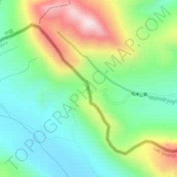
Name: Karakoram Pass topographic map, elevation, terrain.
Location: Karakoram Pass, Nubra, Leh District, Ladakh, India (35.51341 77.82265 35.51351 77.82275)
Average elevation: 18,114 ft
Minimum elevation: 17,388 ft
Maximum elevation: 19,459 ft
Make a donation
Gear up for your next adventure:
As an Amazon Associate, this site earns from qualifying purchases at no extra cost to you.