
Make a donation
Gear up for your next adventure:
As an Amazon Associate, this site earns from qualifying purchases at no extra cost to you.
Oakville topographic map
Click on the map to display elevation.
Make a donation
Gear up for your next adventure:
As an Amazon Associate, this site earns from qualifying purchases at no extra cost to you.
About this map
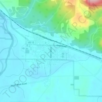
Name: Oakville topographic map, elevation, terrain.
Location: Oakville, Grays Harbor County, Washington, United States (46.83272 -123.24275 46.84587 -123.22612)
Average elevation: 144 ft
Minimum elevation: 46 ft
Maximum elevation: 669 ft
Grays Harbor County trails, hiking, mountain biking, running and outdoor activities
Make a donation
Gear up for your next adventure:
As an Amazon Associate, this site earns from qualifying purchases at no extra cost to you.
Other topographic maps
Click on a map to view its topography, its elevation and its terrain.
Make a donation
Gear up for your next adventure:
As an Amazon Associate, this site earns from qualifying purchases at no extra cost to you.
Roosevelt Beach Conservation Area
United States > Washington > Grays Harbor County > Ocean Grove
Average elevation: 59 ft
Make a donation
Gear up for your next adventure:
As an Amazon Associate, this site earns from qualifying purchases at no extra cost to you.
Roosevelt Beach Conservation Area
United States > Washington > Grays Harbor County > Ocean Grove
Average elevation: 59 ft
Make a donation
Gear up for your next adventure:
As an Amazon Associate, this site earns from qualifying purchases at no extra cost to you.
McCleary
United States > Washington > Grays Harbor County > McCleary > McCleary
Average elevation: 354 ft