
Make a donation
Gear up for your next adventure:
As an Amazon Associate, this site earns from qualifying purchases at no extra cost to you.
Longonot topographic map
Click on the map to display elevation.
Make a donation
Gear up for your next adventure:
As an Amazon Associate, this site earns from qualifying purchases at no extra cost to you.
Longonot
Mount Longonot is protected by Kenya Wildlife Service as part of Mount Longonot National Park. A 3.1 km trail runs from the park entrance up to the crater rim, and continues in a 7.2 km loop encircling the crater. The whole tour (gate-around the rim-gate) of 13.5 km takes about 4–5 hours allowing for necessary rest breaks - parts of the trail are heavily eroded and very steep. The gate elevation is around 2150 m and the peak at 2776 m but following the jagged rim involves substantially more than the 630 m vertical difference.
Make a donation
Gear up for your next adventure:
As an Amazon Associate, this site earns from qualifying purchases at no extra cost to you.
About this map
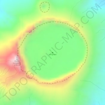
Name: Longonot topographic map, elevation, terrain.
Location: Longonot, Mai Mahiu ward, Naivasha, Nakuru, Rift Valley, Kenya (-0.91449 36.45641 -0.91439 36.45651)
Average elevation: 8,002 ft
Minimum elevation: 7,251 ft
Maximum elevation: 9,049 ft
Make a donation
Gear up for your next adventure:
As an Amazon Associate, this site earns from qualifying purchases at no extra cost to you.