Geolocate

Dixie topographic map

Click on the map to display elevation.

About this map

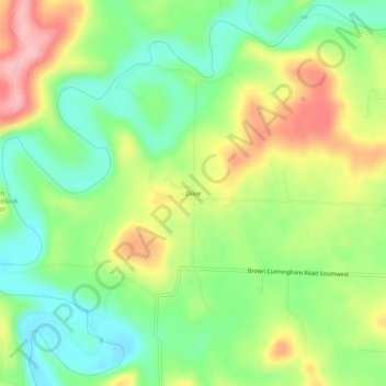
Name: Dixie topographic map, elevation, terrain.

Location: Dixie, Harrison County, Indiana, United States (38.14007 -86.23220 38.18007 -86.19220)

Average elevation: 591 ft

Minimum elevation: 404 ft

Maximum elevation: 850 ft

Harrison County trails, hiking, mountain biking, running and outdoor activities

Other topographic maps

Click on a map to view its topography, its elevation and its terrain.

Lanesville

United States > Indiana > Harrison County

Average elevation: 784 ft

New Amsterdam

United States > Indiana > Harrison County

Average elevation: 495 ft

New Middletown

United States > Indiana > Harrison County

Average elevation: 705 ft

Crandall

United States > Indiana > Harrison County

Average elevation: 712 ft

Laconia

United States > Indiana > Harrison County

Average elevation: 659 ft

Gear up for your next adventure:

🦟Ultrasonic Repellers - Create a bug-free zone at your camp or rest stop
🧭Hiking Compass - Precision compass for reliable navigation in the wilderness
🧭GPS Watch Accessories - Bands and chargers for GPS watches
🌡️Portable Weather Meter - Track weather conditions on the trail
🧥Men's Rain Shells - Premium waterproof and breathable jackets for mountain weather

As an Amazon Associate, this site earns from qualifying purchases at no extra cost to you.