
Crecora topographic map
Click on the map to display elevation.
About this map
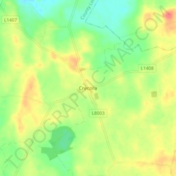
Name: Crecora topographic map, elevation, terrain.
Average elevation: 121 ft
Minimum elevation: 43 ft
Maximum elevation: 207 ft
Other topographic maps
Click on a map to view its topography, its elevation and its terrain.
Curraghchase
Ireland > County Limerick > The Municipal District of Adare — Rathkeale
Average elevation: 112 ft
Courtmatrix
Ireland > County Limerick > The Municipal District of Adare — Rathkeale
Average elevation: 128 ft
Askeaton
Ireland > County Limerick > The Municipal District of Adare — Rathkeale
Average elevation: 43 ft
Adare
Ireland > County Limerick > The Municipal District of Adare — Rathkeale
Average elevation: 39 ft
Deelish
Ireland > County Limerick > The Municipal District of Adare — Rathkeale
Average elevation: 148 ft
Adare
Ireland > County Limerick > The Municipal District of Adare — Rathkeale
Average elevation: 36 ft
Kilmacow
Ireland > County Limerick > The Municipal District of Adare — Rathkeale
Average elevation: 308 ft
Ballyneety
Ireland > County Limerick > The Municipal District of Adare — Rathkeale
Average elevation: 230 ft
Gortroe
Ireland > County Limerick > The Municipal District of Adare — Rathkeale
Average elevation: 138 ft
Ballingarry
Ireland > County Limerick > The Municipal District of Adare — Rathkeale
Average elevation: 308 ft
Bleach Lough
Ireland > County Limerick > The Municipal District of Adare — Rathkeale
Average elevation: 33 ft
Granagh
Ireland > County Limerick > The Municipal District of Adare — Rathkeale
Average elevation: 295 ft
Dromard
Ireland > County Limerick > The Municipal District of Adare — Rathkeale
Average elevation: 128 ft
Flean Beg
Ireland > County Limerick > The Municipal District of Adare — Rathkeale
Average elevation: 358 ft
Knockpatrick
Ireland > County Limerick > The Municipal District of Adare — Rathkeale
Average elevation: 292 ft
Knockdromin
Ireland > County Limerick > The Municipal District of Adare — Rathkeale
Average elevation: 98 ft
Creeves
Ireland > County Limerick > The Municipal District of Adare — Rathkeale
Average elevation: 98 ft
Finnoo
Ireland > County Limerick > The Municipal District of Adare — Rathkeale
Average elevation: 289 ft
Enniscoush
Ireland > County Limerick > The Municipal District of Adare — Rathkeale
Average elevation: 125 ft
Knockbweeheen
Ireland > County Limerick > The Municipal District of Adare — Rathkeale
Average elevation: 394 ft
Croom
Ireland > County Limerick > The Municipal District of Adare — Rathkeale
Average elevation: 102 ft
Rossard
Ireland > County Limerick > The Municipal District of Adare — Rathkeale
Average elevation: 184 ft
Rathkeale
Ireland > County Limerick > The Municipal District of Adare — Rathkeale
Average elevation: 125 ft
Knockpatrick
Ireland > County Limerick > The Municipal District of Adare — Rathkeale
Average elevation: 292 ft