
Thank you for supporting this site ❤️
Make a donation
Make a donation
Gear up for your next adventure:
As an Amazon Associate, this site earns from qualifying purchases at no extra cost to you.
Bellaire topographic map
Click on the map to display elevation.
Thank you for supporting this site ❤️
Make a donation
Make a donation
Gear up for your next adventure:
As an Amazon Associate, this site earns from qualifying purchases at no extra cost to you.
About this map
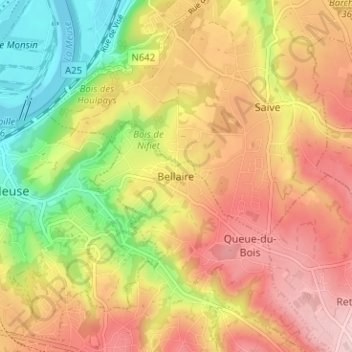
Name: Bellaire topographic map, elevation, terrain.
Location: Bellaire, Beyne-Heusay, Liège, Wallonie, 4610, Belgique (50.62471 5.64547 50.66471 5.68547)
Average elevation: 541 ft
Minimum elevation: 177 ft
Maximum elevation: 843 ft
Thank you for supporting this site ❤️
Make a donation
Make a donation
Gear up for your next adventure:
As an Amazon Associate, this site earns from qualifying purchases at no extra cost to you.
Other topographic maps
Click on a map to view its topography, its elevation and its terrain.
4610
Belgique > Liège > Liège > Beyne-Heusay > Queue-du-Bois > Moulins-sous-Fléron
Average elevation: 663 ft