Geolocate

Rockport topographic map

Click on the map to display elevation.

About this map

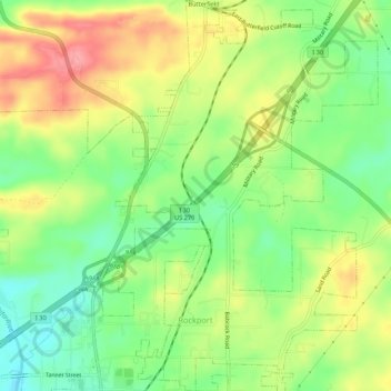
Name: Rockport topographic map, elevation, terrain.

Location: Rockport, Hot Spring County, Arkansas, United States (34.38356 -92.82594 34.42768 -92.78994)

Average elevation: 377 ft

Minimum elevation: 226 ft

Maximum elevation: 558 ft

Hot Spring County trails, hiking, mountain biking, running and outdoor activities

Other topographic maps

Click on a map to view its topography, its elevation and its terrain.

Bonnerdale

United States > Arkansas > Hot Spring County

Average elevation: 663 ft

Social Hill

United States > Arkansas > Hot Spring County

Average elevation: 302 ft

Saginaw

United States > Arkansas > Hot Spring County

Average elevation: 305 ft

Magnet Cove

United States > Arkansas > Hot Spring County

Average elevation: 512 ft

Glen Rose

United States > Arkansas > Hot Spring County

Average elevation: 351 ft

Lono

United States > Arkansas > Hot Spring County

Average elevation: 463 ft

Perla

United States > Arkansas > Hot Spring County > Perla

Average elevation: 358 ft

Gear up for your next adventure:

🎒Outdoor Daypacks - Lightweight backpacks designed for carrying maps and essential gear
🎒Day Hiking Backpack - Lightweight backpack perfect for day trips and outdoor adventures
🏕️Family Camping Gear - Essentials for group camping trips
🧯Portable Fire Pit - Compact fire pit for camping spots
🪶Thermal Camp Blanket - Extra warmth for cold nights

As an Amazon Associate, this site earns from qualifying purchases at no extra cost to you.