
Make a donation
Gear up for your next adventure:
As an Amazon Associate, this site earns from qualifying purchases at no extra cost to you.
Turracher Höhe topographic map
Click on the map to display elevation.
Make a donation
Gear up for your next adventure:
As an Amazon Associate, this site earns from qualifying purchases at no extra cost to you.
Turracher Höhe
The highest point of the approx. two km long pass summit has an altitude of 1,795 m above sea level south of the Turracher Lake. The lake has a water level of 1,763 m above sea (Adria) level and is connected to the village. The Turracher Höhe, as a "classic" pass summit, is also part of a drainage divide between the Mura valley and the Upper Gurk River, whose source is beneath the Lattersteighöhe at approx. 2,000 m above sea level.
Make a donation
Gear up for your next adventure:
As an Amazon Associate, this site earns from qualifying purchases at no extra cost to you.
About this map
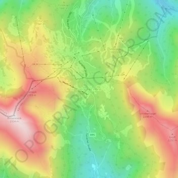
Name: Turracher Höhe topographic map, elevation, terrain.
Average elevation: 6,076 ft
Minimum elevation: 4,731 ft
Maximum elevation: 7,644 ft
Make a donation
Gear up for your next adventure:
As an Amazon Associate, this site earns from qualifying purchases at no extra cost to you.