Geolocate

Burnsall topographic map

Click on the map to display elevation.

About this map

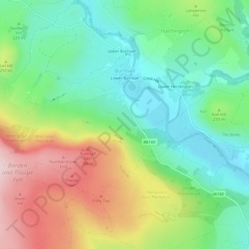
Name: Burnsall topographic map, elevation, terrain.

Location: Burnsall, North Yorkshire, England, United Kingdom (54.02530 -1.98674 54.05617 -1.94303)

Average elevation: 830 ft

Minimum elevation: 433 ft

Maximum elevation: 1,490 ft

Other topographic maps

Click on a map to view its topography, its elevation and its terrain.

Nawton

United Kingdom > England > North Yorkshire

Average elevation: 259 ft

Kirby Hill

United Kingdom > England > North Yorkshire

Average elevation: 643 ft

Glusburn

United Kingdom > England > North Yorkshire

Average elevation: 574 ft

Speeton

United Kingdom > England > North Yorkshire

Average elevation: 233 ft

Nappa

United Kingdom > England > North Yorkshire > Halton West

Average elevation: 505 ft

Pateley Bridge

United Kingdom > England > North Yorkshire

Average elevation: 843 ft

Sutton Bank

United Kingdom > England > North Yorkshire

Average elevation: 787 ft

Street

United Kingdom > England > North Yorkshire > Glaisdale

Average elevation: 673 ft

Great Ayton

United Kingdom > England > North Yorkshire

Average elevation: 564 ft

Holmehead

United Kingdom > England > North Yorkshire > Langcliffe

Average elevation: 840 ft

Botton

United Kingdom > England > North Yorkshire

Average elevation: 932 ft

Runswick Bay

United Kingdom > England > North Yorkshire

Average elevation: 223 ft

Bainbridge

United Kingdom > England > North Yorkshire

Average elevation: 951 ft

Womersley

United Kingdom > England > North Yorkshire

Average elevation: 56 ft

Thixendale

United Kingdom > England > North Yorkshire

Average elevation: 610 ft

Walden Stubbs

United Kingdom > England > North Yorkshire

Average elevation: 39 ft

Heyshaw

United Kingdom > England > North Yorkshire > Harrogate > Heyshaw

Average elevation: 725 ft

Eastfield

United Kingdom > England > North Yorkshire > Scarborough

Average elevation: 164 ft

Gear up for your next adventure:

🧭Compass with Lanyard - Easy‑carry compass for navigation
🪶Compact Camp Shovel - Folding shovel for campsite tasks
🪵Folding Camp Saw - Compact saw for wood and campsite work
🎒Waterproof Dry Bags - Keep your electronics and maps dry inside your pack
📚Navigation Handbooks - Master the art of reading topographic maps and using a compass

As an Amazon Associate, this site earns from qualifying purchases at no extra cost to you.