
Die Hel topographic map
Click on the map to display elevation.
About this map
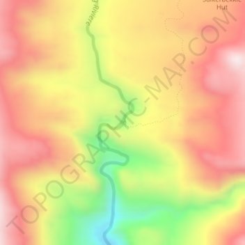
Name: Die Hel topographic map, elevation, terrain.
Average elevation: 2,037 ft
Minimum elevation: 909 ft
Maximum elevation: 2,812 ft
Other topographic maps
Click on a map to view its topography, its elevation and its terrain.
Piketberg
South Africa > Western Cape > West Coast District Municipality > Bergrivier Local Municipality
Average elevation: 869 ft
Porterville
South Africa > Western Cape > West Coast District Municipality > Bergrivier Local Municipality
Average elevation: 679 ft
Redelinghuys
South Africa > Western Cape > West Coast District Municipality > Bergrivier Local Municipality
Average elevation: 348 ft
Velddrif
South Africa > Western Cape > West Coast District Municipality > Bergrivier Local Municipality
Average elevation: 26 ft
Aurora
South Africa > Western Cape > West Coast District Municipality > Bergrivier Local Municipality
Average elevation: 446 ft
Velddrif
South Africa > Western Cape > West Coast District Municipality > Bergrivier Local Municipality > Velddrif
Average elevation: 26 ft
Redelinghuys
South Africa > Western Cape > West Coast District Municipality > Bergrivier Local Municipality
Average elevation: 348 ft
Velddrif
South Africa > Western Cape > West Coast District Municipality > Bergrivier Local Municipality
Average elevation: 26 ft
Piketberg
South Africa > Western Cape > West Coast District Municipality > Bergrivier Local Municipality
Average elevation: 869 ft