Geolocate

Brindle topographic map

Click on the map to display elevation.

About this map

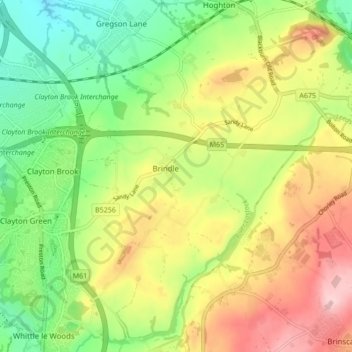
Name: Brindle topographic map, elevation, terrain.

Location: Brindle, Chorley, Lancashire, England, United Kingdom (53.68701 -2.63231 53.73743 -2.57583)

Average elevation: 374 ft

Minimum elevation: 92 ft

Maximum elevation: 728 ft

Gear up for your next adventure:

🏕️Tent Footprint - Protect your tent base from wear
📡Handheld GPS Device - Reliable handheld GPS for outdoor navigation
🧢Sun Protection Hats - Wide-brimmed and UPF-rated hats for high-altitude sun safety
🪶LED Camping Lantern - Bright lantern for camp lighting
Backpacking Tents - Weight-optimized shelters for multi-day topographic surveys

As an Amazon Associate, this site earns from qualifying purchases at no extra cost to you.