
Make a donation
Gear up for your next adventure:
As an Amazon Associate, this site earns from qualifying purchases at no extra cost to you.
Dender topographic map
Click on the map to display elevation.
Make a donation
Gear up for your next adventure:
As an Amazon Associate, this site earns from qualifying purchases at no extra cost to you.
Dender
The Western or Little Dender is 22 kilometres (14 mi) long and springs near Leuze-en-Hainaut at an elevation of about 60 to 70 metres (200 to 230ft) above sea level. The source of the Eastern Dender, which is 39 kilometres (24 mi) long, is near Jurbise at a height of 100 metres (330 ft) above sea level. The two rivers meet in the town of Ath. From that confluence, the river is called the Dender proper. From Ath, the Dender passes into the Denderstreek through the cities and towns of Geraardsbergen, south of which its tributary, the Mark, flows into it. From this confluence, the river continues to flow through Ninove, Denderleeuw, and Aalst, before ending in Dendermonde. The Dender is navigable up to Aalst for small ships up to 600 tons and further upstream for ships up to 350 tons. The Molenbeek-Ter Erpenbeek flows into the Dender at Hofstade.
Make a donation
Gear up for your next adventure:
As an Amazon Associate, this site earns from qualifying purchases at no extra cost to you.
About this map
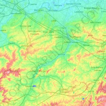
Name: Dender topographic map, elevation, terrain.
Location: Dender, Aalst, East Flanders, Flanders, Belgium (50.63536 3.77462 51.04489 4.08958)
Average elevation: 138 ft
Minimum elevation: -85 ft
Maximum elevation: 518 ft
Make a donation
Gear up for your next adventure:
As an Amazon Associate, this site earns from qualifying purchases at no extra cost to you.