
Make a donation
Gear up for your next adventure:
As an Amazon Associate, this site earns from qualifying purchases at no extra cost to you.
Lichtenfels topographic map
Click on the map to display elevation.
Make a donation
Gear up for your next adventure:
As an Amazon Associate, this site earns from qualifying purchases at no extra cost to you.
Lichtenfels
Bohnberg | Buch am Forst | Burgberg | Degendorf | Eichig | Friesenhof | Gnellenroth | Hammer | Heinach | Isling | Karolinenhöhe | Klosterlangheim | Kösten | Köttel | Krappenroth | Lahm | Mistelfeld | Mönchkröttendorf | Nassanger | Oberlangheim | Oberwallenstadt | Reundorf | Roth | Rothmannsthal | Schney | Schönsreuth | Seehof | Seubelsdorf | Stetten | Stöcken | Tiefenroth | Trieb | Unterwallenstadt | Weingarten
Make a donation
Gear up for your next adventure:
As an Amazon Associate, this site earns from qualifying purchases at no extra cost to you.
About this map
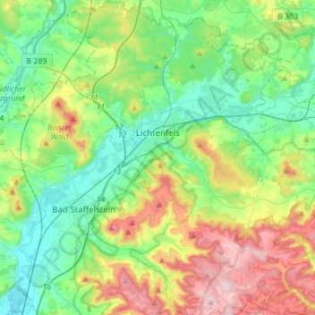
Name: Lichtenfels topographic map, elevation, terrain.
Location: Lichtenfels, Landkreis Lichtenfels, Bayern, 96215, Deutschland (50.04347 10.97516 50.21959 11.18991)
Average elevation: 1,142 ft
Minimum elevation: 797 ft
Maximum elevation: 1,886 ft
Make a donation
Gear up for your next adventure:
As an Amazon Associate, this site earns from qualifying purchases at no extra cost to you.
Other topographic maps
Click on a map to view its topography, its elevation and its terrain.
Schwürbitz
Deutschland > Bayern > Landkreis Lichtenfels
Schwürbitz liegt am Main, auf einer Höhe von 287 m ü. NHN und hat 1446 Einwohner (Stand: 30. Juni 2017). Es liegt am nördlichsten Punkt des Mains.
Average elevation: 958 ft
Schwabthal
Deutschland > Bayern > Landkreis Lichtenfels > Bad Staffelstein
Average elevation: 1,417 ft