Geolocate

Middleton topographic map

Click on the map to display elevation.

About this map

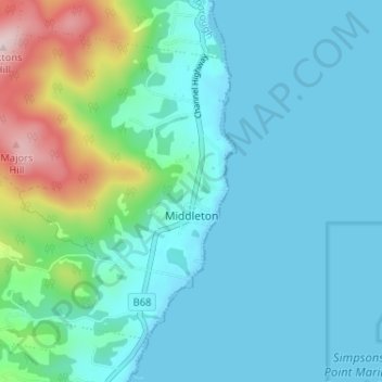
Name: Middleton topographic map, elevation, terrain.

Location: Middleton, Kingborough, Tasmania, Australia (-43.24858 147.19626 -43.20899 147.26097)

Average elevation: 292 ft

Minimum elevation: 0 ft

Maximum elevation: 1,621 ft

Other topographic maps

Click on a map to view its topography, its elevation and its terrain.

Cathedral Mountain

Australia > Tasmania

Average elevation: 3,255 ft

The Nut

Australia > Tasmania > Stanley

Average elevation: 26 ft

Waterworks Reserve

Australia > Tasmania > Hobart

Average elevation: 787 ft

Rowlands Hill

Australia > Tasmania

Average elevation: 1,273 ft

Bream Creek

Australia > Tasmania > Bream Creek

Average elevation: 115 ft

Cradle Mountain

Australia > Tasmania > Cradle Mountain

Average elevation: 3,753 ft

West Gawler River

Australia > Tasmania > Sprent > Gawler

Average elevation: 659 ft

Mount Patrick

Australia > Tasmania

Average elevation: 2,831 ft

Mount Tyndall

Australia > Tasmania

Average elevation: 2,986 ft

Mount Ossa

Australia > Tasmania

Average elevation: 3,996 ft

Gear up for your next adventure:

🥾Hiking Shoes - Durable and comfortable shoes for trail hiking
🧣Hiking Neck Gaiter - Multi‑use neck protection for outdoor weather
🪶Wildlife Field Guides - Learn animal tracking and species ID
🔌Solar Panel Charger - Charge gear sustainably outdoors
🧺Microfiber Travel Towels - Compact and fast-drying towels for trail use

As an Amazon Associate, this site earns from qualifying purchases at no extra cost to you.