Geolocate

Lengatz topographic map

Click on the map to display elevation.

About this map

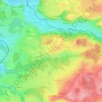
Name: Lengatz topographic map, elevation, terrain.

Location: Lengatz, Hergatz, Landkreis Lindau, Bayern, 88178, Deutschland (47.63276 9.87458 47.67276 9.91458)

Average elevation: 2,087 ft

Minimum elevation: 1,864 ft

Maximum elevation: 2,343 ft

Gear up for your next adventure:

🦺Reflective Outdoor Gear - Safety gear for low‑light conditions
🧴Hand Sanitizer - Keep hands clean while hiking
🔦Compact Flashlight - Reliable flashlight for emergencies
🪑Portable Camp Table - Compact table for campsite meals
📚USA Hiking Guide Books - Top trail guides and map books

As an Amazon Associate, this site earns from qualifying purchases at no extra cost to you.