
Make a donation
Gear up for your next adventure:
As an Amazon Associate, this site earns from qualifying purchases at no extra cost to you.
Abapó topographic map
Click on the map to display elevation.
Make a donation
Gear up for your next adventure:
As an Amazon Associate, this site earns from qualifying purchases at no extra cost to you.
Abapó
Abapó es la ciudad más poblada del municipio de Cabezas y se sitúa a una altitud de 445 msnm en la margen izquierda del río Grande, que llega finalmente a las tierras bajas bolivianas.
Make a donation
Gear up for your next adventure:
As an Amazon Associate, this site earns from qualifying purchases at no extra cost to you.
About this map
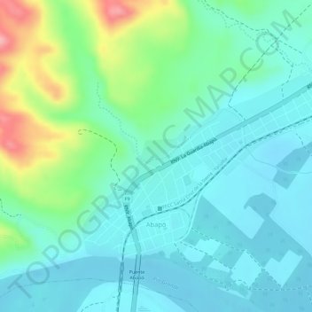
Name: Abapó topographic map, elevation, terrain.
Average elevation: 1,519 ft
Minimum elevation: 1,407 ft
Maximum elevation: 1,827 ft
Make a donation
Gear up for your next adventure:
As an Amazon Associate, this site earns from qualifying purchases at no extra cost to you.
Other topographic maps
Click on a map to view its topography, its elevation and its terrain.
Abapó
Bolivia > Santa Cruz > Provincia Cordillera > Municipio Cabezas
Abapó es la ciudad más poblada del municipio de Cabezas y se sitúa a una altitud de 445 m s. n. m. en la margen izquierda del río Grande, que llega finalmente a las tierras bajas bolivianas.
Average elevation: 1,503 ft
Concepcion
Bolivia > Santa Cruz > Provincia Cordillera > Municipio Cabezas
Average elevation: 1,450 ft