Geolocate

Hamlin topographic map

Click on the map to display elevation.

About this map

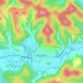
Name: Hamlin topographic map, elevation, terrain.

Location: Hamlin, Lincoln County, West Virginia, 25523, United States (38.27359 -82.12797 38.29342 -82.09448)

Average elevation: 791 ft

Minimum elevation: 610 ft

Maximum elevation: 1,063 ft

Lincoln County trails, hiking, mountain biking, running and outdoor activities

Other topographic maps

Click on a map to view its topography, its elevation and its terrain.

Ranger

United States > West Virginia > Lincoln County

Average elevation: 853 ft

Sod

United States > West Virginia > Lincoln County

Average elevation: 948 ft

Branchland

United States > West Virginia > Lincoln County

Average elevation: 778 ft

Alkol

United States > West Virginia > Lincoln County > Alkol

Average elevation: 997 ft

Gear up for your next adventure:

💧Water Purification System - Clean water on the trail with reliable purifiers
🦺Reflective Outdoor Gear - Safety gear for low‑light conditions
📚Navigation Handbooks - Master the art of reading topographic maps and using a compass
🌎3D Topographic Globes - Raised relief globes for a tactile understanding of geography
🪶Wildlife Field Guides - Learn animal tracking and species ID

As an Amazon Associate, this site earns from qualifying purchases at no extra cost to you.