Geolocate

Alta topographic map

Click on the map to display elevation.

About this map

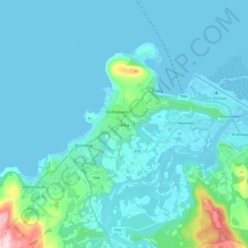
Name: Alta topographic map, elevation, terrain.

Location: Alta, Troms og Finnmark, 9511, Norway (69.92660 23.23333 70.00660 23.31333)

Average elevation: 112 ft

Minimum elevation: -10 ft

Maximum elevation: 1,132 ft

Other topographic maps

Click on a map to view its topography, its elevation and its terrain.

Hammerfest

Norway > Troms og Finnmark

Average elevation: 459 ft

Balsfjord

Norway > Troms og Finnmark

Average elevation: 1,247 ft

Deatnu

Norway > Troms og Finnmark

Average elevation: 768 ft

Loppa

Norway > Troms og Finnmark

Average elevation: 295 ft

Gear up for your next adventure:

🩳Quick‑Dry Hiking Shorts - Comfortable and quick‑dry shorts for summer hiking
📦Dry Bags Set - Waterproof storage for electronics and clothes
☀️Outdoor Sunscreen - High protection sunscreen for outdoor activities
🗻Climbing Gear Basics - Essential gear for beginner climbers
🧣Merino Neck Gaiters - Multi-functional headwear for wind and sun protection

As an Amazon Associate, this site earns from qualifying purchases at no extra cost to you.