
Hamlet of Lamoureux topographic map
Interactive map
Click on the map to display elevation.
About this map
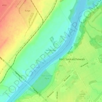
Name: Hamlet of Lamoureux topographic map, elevation, terrain.
Location: Hamlet of Lamoureux, Sturgeon County, Alberta, Canada (53.71104 -113.23115 53.71894 -113.21846)
Average elevation: 2,037 ft
Minimum elevation: 1,962 ft
Maximum elevation: 2,133 ft
Other topographic maps
Click on a map to view its topography, its elevation and its terrain.
Redwater Provincial Recreation Area
Canada > Alberta > Sturgeon County
Redwater Provincial Recreation Area, Township Road 571A, Sturgeon County, Alberta, Canada
Average elevation: 2,054 ft
Rivière Qui Barre
Canada > Alberta > Sturgeon County
Rivière Qui Barre, Sturgeon County, Alberta, Canada
Average elevation: 2,228 ft
Hamlet of Rivière Qui Barre
Canada > Alberta > Sturgeon County
Hamlet of Rivière Qui Barre, Sturgeon County, Alberta, Canada
Average elevation: 2,254 ft
Hamlet of Calahoo
Canada > Alberta > Sturgeon County
Hamlet of Calahoo, Sturgeon County, Alberta, Canada
Average elevation: 2,241 ft