
Make a donation
Gear up for your next adventure:
As an Amazon Associate, this site earns from qualifying purchases at no extra cost to you.
Esen topographic map
Click on the map to display elevation.
Make a donation
Gear up for your next adventure:
As an Amazon Associate, this site earns from qualifying purchases at no extra cost to you.
Esen
Esen ligt aan de noordzijde van de Midden-West-Vlaamse Heuvelrug op een hoogte van ongeveer 7 meter. In het noorden ligt de lagere vallei van de Handzamevaart, een ingepolderde voormalige arm van de IJzervallei. Hier liggen de Betoosterse broeken en het Esenbroek op een hoogte van ongeveer 5 meter. Het zuiden van Esen behoort tot Zandlemig Vlaanderen en de hoogte loopt op tot bijna 40 meter. Hier vindt men vooral akkerbouw.
Make a donation
Gear up for your next adventure:
As an Amazon Associate, this site earns from qualifying purchases at no extra cost to you.
About this map
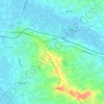
Name: Esen topographic map, elevation, terrain.
Location: Esen, Diksmuide, West-Vlaanderen, België (51.00231 2.84698 51.03909 2.95046)
Average elevation: 30 ft
Minimum elevation: -10 ft
Maximum elevation: 138 ft
Make a donation
Gear up for your next adventure:
As an Amazon Associate, this site earns from qualifying purchases at no extra cost to you.
Other topographic maps
Click on a map to view its topography, its elevation and its terrain.