Geolocate

Arties topographic map

Click on the map to display elevation.

About this map

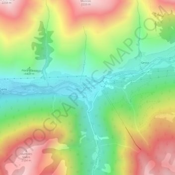
Name: Arties topographic map, elevation, terrain.

Location: Arties, Naut Aran, Val d'Aran, Lleida, Catalonia, 25539, Spain (42.68005 0.85207 42.72005 0.89207)

Average elevation: 5,144 ft

Minimum elevation: 3,596 ft

Maximum elevation: 7,274 ft

Gear up for your next adventure:

🏥Hiking First Aid Kits - Comprehensive medical kits for remote trail injuries
🪓Survival Multi‑Tool - Versatile tool for camp and trail tasks
🎒Outdoor Daypacks - Lightweight backpacks designed for carrying maps and essential gear
🔌Solar Panel Charger - Charge gear sustainably outdoors
🦟Ultrasonic Repellers - Create a bug-free zone at your camp or rest stop

As an Amazon Associate, this site earns from qualifying purchases at no extra cost to you.