Geolocate

Trecate topographic map

Click on the map to display elevation.

About this map

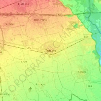
Name: Trecate topographic map, elevation, terrain.

Location: Trecate, Novara, Piemonte, 28069, Italia (45.39797 8.66888 45.46599 8.81198)

Average elevation: 440 ft

Minimum elevation: 341 ft

Maximum elevation: 525 ft

Other topographic maps

Click on a map to view its topography, its elevation and its terrain.

Sovazza

Italia > Piemonte > Novara

Average elevation: 2,238 ft

Gaggiolo

Italia > Piemonte > Novara

Average elevation: 692 ft

Gattico

Italia > Piemonte > Novara

Average elevation: 1,109 ft

Fosseno

Italia > Piemonte > Novara

Average elevation: 1,798 ft

Coiromonte

Italia > Piemonte > Novara

Average elevation: 2,425 ft

Tabarino

Italia > Piemonte > Novara

Average elevation: 1,821 ft

Gear up for your next adventure:

🌡️Handheld Weather Meters - Measure wind, temp, and pressure for safe mountain travel
💧Water Purification System - Clean water on the trail with reliable purifiers
📦Gear Storage Bags - Organize and protect outdoor equipment
👟Trail Running Shoes - Lightweight shoes for trail runners
🔦LED Headlamp - Bright and durable LED headlamp for night navigation

As an Amazon Associate, this site earns from qualifying purchases at no extra cost to you.