Geolocate

Ushguli topographic map

Interactive map

Click on the map to display elevation.

About this map

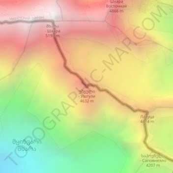
Name: Ushguli topographic map, elevation, terrain.

Location: Ushguli, Mestia Municipality, Samegrelo-Upper Svaneti, Georgia (42.98908 43.12041 42.98918 43.12051)

Average elevation: 13,547 ft

Minimum elevation: 9,436 ft

Maximum elevation: 17,139 ft

Other topographic maps

Click on a map to view its topography, its elevation and its terrain.

Zemo Chobani

Georgia > Samegrelo-Upper Svaneti > Mestia Municipality > Tsvirmi

Zemo Chobani, Tsvirmi, Mestia Municipality, Samegrelo-Upper Svaneti, Georgia

Average elevation: 6,106 ft

Adishi

Georgia > Samegrelo-Upper Svaneti > Mestia Municipality

Adishi, Mestia Municipality, Samegrelo-Upper Svaneti, Georgia

Average elevation: 13,527 ft

Tetnuldi

Georgia > Samegrelo-Upper Svaneti > Mestia Municipality

Tetnuldi, Mestia Municipality, Samegrelo-Upper Svaneti, Georgia

Average elevation: 13,176 ft

Mestia

Georgia > Samegrelo-Upper Svaneti > Mestia Municipality

Mestia, Mestia Municipality, Samegrelo-Upper Svaneti, Georgia

Average elevation: 5,807 ft