
Thank you for supporting this site ❤️
Make a donation
Make a donation
Gear up for your next adventure:
As an Amazon Associate, this site earns from qualifying purchases at no extra cost to you.
Tres Valles topographic map
Click on the map to display elevation.
Thank you for supporting this site ❤️
Make a donation
Make a donation
Gear up for your next adventure:
As an Amazon Associate, this site earns from qualifying purchases at no extra cost to you.
About this map
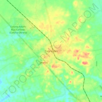
Name: Tres Valles topographic map, elevation, terrain.
Location: Tres Valles, Veracruz, México (18.20056 -96.17500 18.28056 -96.09500)
Average elevation: 115 ft
Minimum elevation: 43 ft
Maximum elevation: 223 ft
Thank you for supporting this site ❤️
Make a donation
Make a donation
Gear up for your next adventure:
As an Amazon Associate, this site earns from qualifying purchases at no extra cost to you.
Other topographic maps
Click on a map to view its topography, its elevation and its terrain.
glorieta niños heroes
México > Veracruz > Tres Valles > Colonia Adolfo Ruiz Cortines (Colonia Obrera)
Average elevation: 105 ft