Geolocate

Kipolot topographic map

Click on the map to display elevation.

About this map

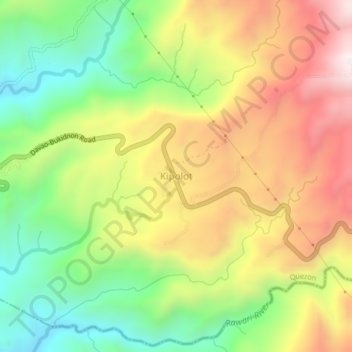
Name: Kipolot topographic map, elevation, terrain.

Location: Kipolot, Quezon, Bukidnon, Northern Mindanao, Philippines (7.58243 125.14996 7.62243 125.18996)

Average elevation: 2,333 ft

Minimum elevation: 1,122 ft

Maximum elevation: 3,714 ft

Other topographic maps

Click on a map to view its topography, its elevation and its terrain.

Manuto River

Philippines > Bukidnon > Quezon > Cawayan

Average elevation: 1,329 ft

Pulangi Lake

Philippines > Bukidnon > Quezon

Average elevation: 988 ft

Gear up for your next adventure:

👟Trail Running Shoes - Lightweight shoes for trail runners
📡Handheld GPS Device - Reliable handheld GPS for outdoor navigation
🧦Hiking Socks - Comfortable socks to prevent blisters on long hikes
🧭Map Reading Tools - Tools and kits for map navigation
🌡️Portable Weather Meter - Track weather conditions on the trail

As an Amazon Associate, this site earns from qualifying purchases at no extra cost to you.