Geolocate

Senmonorom topographic map

Click on the map to display elevation.

About this map

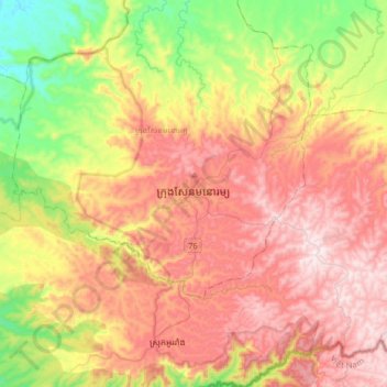
Name: Senmonorom topographic map, elevation, terrain.

Location: Senmonorom, Mondulkiri, 110502, Cambodia (12.29686 107.02652 12.61686 107.34652)

Average elevation: 1,926 ft

Minimum elevation: 810 ft

Maximum elevation: 3,028 ft

Gear up for your next adventure:

🦺Reflective Outdoor Gear - Safety gear for low‑light conditions
📚USA Hiking Guide Books - Top trail guides and map books
📖Nature Tracking Books - Learn to track wildlife and terrain
🪶Paracord Bracelet - Survival bracelet with built‑in tools
🕶️GPS Smartphone Mount - Secure mount for phone navigation

As an Amazon Associate, this site earns from qualifying purchases at no extra cost to you.