
Make a donation
Gear up for your next adventure:
As an Amazon Associate, this site earns from qualifying purchases at no extra cost to you.
Orlová topographic map
Click on the map to display elevation.
Make a donation
Gear up for your next adventure:
As an Amazon Associate, this site earns from qualifying purchases at no extra cost to you.
Orlová
The name is most probably possessive in origin, derived from the personal Slavic name Orel / Orzeł (literally "eagle" in English), although it may also be of topographic origins.
Make a donation
Gear up for your next adventure:
As an Amazon Associate, this site earns from qualifying purchases at no extra cost to you.
About this map
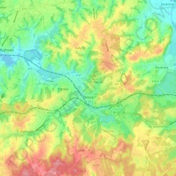
Name: Orlová topographic map, elevation, terrain.
Average elevation: 820 ft
Minimum elevation: 682 ft
Maximum elevation: 997 ft
Make a donation
Gear up for your next adventure:
As an Amazon Associate, this site earns from qualifying purchases at no extra cost to you.
Other topographic maps
Click on a map to view its topography, its elevation and its terrain.
jez Děhylov - 12,1 km
Czechia > Moravia-Silesia > Moravskoslezský kraj > Dobroslavice
Average elevation: 794 ft