
Boston Harbor Islands National Recreation Area topographic map
Interactive map
Click on the map to display elevation.
About this map
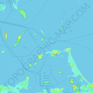
Name: Boston Harbor Islands National Recreation Area topographic map, elevation, terrain.
Average elevation: 3 ft
Minimum elevation: -7 ft
Maximum elevation: 154 ft
Other topographic maps
Click on a map to view its topography, its elevation and its terrain.
East Weymouth
United States > Massachusetts > Norfolk County > Weymouth
East Weymouth, Weymouth, Norfolk County, Massachusetts, 02189, United States
Average elevation: 69 ft
Weymouth Heights
United States > Massachusetts > Norfolk County > Weymouth
Weymouth Heights, Weymouth, Norfolk County, Massachusetts, 02191, United States
Average elevation: 49 ft