
Make a donation
Gear up for your next adventure:
As an Amazon Associate, this site earns from qualifying purchases at no extra cost to you.
El Naranjo topographic map
Click on the map to display elevation.
Make a donation
Gear up for your next adventure:
As an Amazon Associate, this site earns from qualifying purchases at no extra cost to you.
El Naranjo
El Naranjo is located in an extensive area of tropical and semi-tropical mountains and lowlands called La Huasteca after the Indian civilization and people inhabiting the region. The town of El Naranjo is in the foothills of the Sierra Madre Oriental. It received its name because previously an orchard of orange trees (naranjos) was located at the townsite. The municipality consists mostly of forested mountains with elevations of up to 5,000 feet (1,500 m) and valleys cultivated mostly in sugar cane. A large sugar refinery is located in the town of El Naranjo.
Make a donation
Gear up for your next adventure:
As an Amazon Associate, this site earns from qualifying purchases at no extra cost to you.
About this map
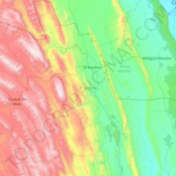
Name: El Naranjo topographic map, elevation, terrain.
Location: El Naranjo, San Luis Potosí, Mexico (22.14646 -99.54433 22.74850 -99.20609)
Average elevation: 2,405 ft
Minimum elevation: 269 ft
Maximum elevation: 6,352 ft
Make a donation
Gear up for your next adventure:
As an Amazon Associate, this site earns from qualifying purchases at no extra cost to you.
Other topographic maps
Click on a map to view its topography, its elevation and its terrain.
San Luis Potosí City
Mexico > San Luis Potosi > Municipio de San Luis Potosí
San Luis Potosí, commonly called SLP or simply San Luis, is the capital and the most populous city of the Mexican state of San Luis Potosí. It is the municipal seat of the surrounding municipality of San Luis Potosí. The city lies at an elevation of 1,864 metres (6,115 feet). It has an estimated population…
Average elevation: 6,575 ft
San Luis Potosí City
Mexico > San Luis Potosi > Municipio de San Luis Potosí
San Luis Potosí, commonly referred to as San Luis, or by its initials SLP (Otomi: Nmiñ'u), is the capital and the most populous city of the Mexican state of San Luis Potosí. It is the municipal seat of the surrounding municipality of San Luis Potosí. The city lies at an elevation of 1,864 metres (6,115…
Average elevation: 6,575 ft
Make a donation
Gear up for your next adventure:
As an Amazon Associate, this site earns from qualifying purchases at no extra cost to you.
Make a donation
Gear up for your next adventure:
As an Amazon Associate, this site earns from qualifying purchases at no extra cost to you.
San Luis Potosí City
San Luis Potosí, commonly referred to as San Luis, or by its initials SLP (Otomi: Nmiñ'u), is the capital and the most populous city of the Mexican state of San Luis Potosí. It is the municipal seat of the surrounding municipality of San Luis Potosí. The city lies at an elevation of 1,864 metres (6,115…
Average elevation: 6,575 ft
Matehuala
Mexico > San Luis Potosi > Matehuala
Matehuala is a city in the Mexican state of San Luis Potosí, situated at an elevation of about 1,500 m. Matehuala is also the municipal seat of the municipality of the same name, located in the northern part of the state, on the border with the southwestern corner of Nuevo León. The municipality of Matehuala…
Average elevation: 5,755 ft
Make a donation
Gear up for your next adventure:
As an Amazon Associate, this site earns from qualifying purchases at no extra cost to you.
San Luis Potosí City
Mexico > San Luis Potosi > Municipio de San Luis Potosí
San Luis Potosí, commonly referred to as San Luis, or by its initials SLP (Otomi: Nmiñ'u), is the capital and the most populous city of the Mexican state of San Luis Potosí. It is the municipal seat of the surrounding municipality of San Luis Potosí. The city lies at an elevation of 1,864 metres (6,115…
Average elevation: 6,575 ft
Make a donation
Gear up for your next adventure:
As an Amazon Associate, this site earns from qualifying purchases at no extra cost to you.
Make a donation
Gear up for your next adventure:
As an Amazon Associate, this site earns from qualifying purchases at no extra cost to you.
Guadalupe de los Faz
Mexico > San Luis Potosi > Matehuala > Guadalupe de los Faz
Average elevation: 5,443 ft
Cerrito de la Cruz
Mexico > San Luis Potosi > Municipio de San Luis Potosí > San Luis Potosí
Average elevation: 6,247 ft