
Make a donation
Gear up for your next adventure:
As an Amazon Associate, this site earns from qualifying purchases at no extra cost to you.
El Tablón topographic map
Click on the map to display elevation.
Make a donation
Gear up for your next adventure:
As an Amazon Associate, this site earns from qualifying purchases at no extra cost to you.
About this map
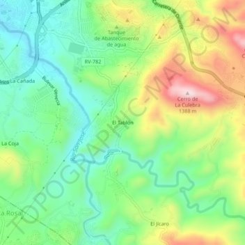
Name: El Tablón topographic map, elevation, terrain.
Average elevation: 3,658 ft
Minimum elevation: 3,173 ft
Maximum elevation: 4,498 ft
Make a donation
Gear up for your next adventure:
As an Amazon Associate, this site earns from qualifying purchases at no extra cost to you.
Other topographic maps
Click on a map to view its topography, its elevation and its terrain.
Barrio El Calvario
Honduras > Francisco Morazán > Distrito Central > Tegucigalpa
Average elevation: 3,163 ft
Colonia Residencial Santa Cruz
Honduras > Francisco Morazán > Distrito Central > Tegucigalpa
Average elevation: 3,717 ft
Colonia San Juan Bosco
Honduras > Francisco Morazán > Distrito Central > Tegucigalpa
Average elevation: 3,885 ft
Parque El Trapiche
Honduras > Francisco Morazán > Distrito Central > Tegucigalpa
Average elevation: 3,415 ft
Make a donation
Gear up for your next adventure:
As an Amazon Associate, this site earns from qualifying purchases at no extra cost to you.
Rio Grande o Choluteca
Honduras > Francisco Morazán > Distrito Central > Tegucigalpa > Comayagüela
Average elevation: 3,173 ft
Colonia Los Ángeles
Honduras > Francisco Morazán > Distrito Central > Tegucigalpa
Average elevation: 3,415 ft
Represa Los Laureles
Honduras > Francisco Morazán > Distrito Central > Tegucigalpa
Average elevation: 3,488 ft
Make a donation
Gear up for your next adventure:
As an Amazon Associate, this site earns from qualifying purchases at no extra cost to you.