
Make a donation
Gear up for your next adventure:
As an Amazon Associate, this site earns from qualifying purchases at no extra cost to you.
Malavuwe topographic map
Click on the map to display elevation.
Make a donation
Gear up for your next adventure:
As an Amazon Associate, this site earns from qualifying purchases at no extra cost to you.
About this map
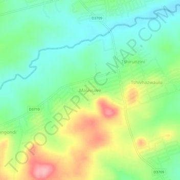
Name: Malavuwe topographic map, elevation, terrain.
Average elevation: 1,713 ft
Minimum elevation: 1,555 ft
Maximum elevation: 1,978 ft
Make a donation
Gear up for your next adventure:
As an Amazon Associate, this site earns from qualifying purchases at no extra cost to you.
Other topographic maps
Click on a map to view its topography, its elevation and its terrain.
Mutale
South Africa > Limpopo > Vhembe District Municipality > Thulamela Local Municipality
Average elevation: 3,333 ft
Nandoni Dam
South Africa > Limpopo > Vhembe District Municipality > Thulamela Local Municipality
Average elevation: 1,650 ft
Mutshindudi
South Africa > Limpopo > Vhembe District Municipality > Thulamela Local Municipality
The Mutshindudi River is a river in the Limpopo Province of South Africa, it originates in the Soutpansberg mountains. It is a right-hand tributary of the Levuvhu River. Its elevation is 534 metres above the sea level. It is about 50 km long and drops steeply from a high rain fall region at 1200m to a lowland…
Average elevation: 2,303 ft
Nandoni Dam
South Africa > Limpopo > Vhembe District Municipality > Thulamela Local Municipality
Average elevation: 1,650 ft
Make a donation
Gear up for your next adventure:
As an Amazon Associate, this site earns from qualifying purchases at no extra cost to you.