
Make a donation
Gear up for your next adventure:
As an Amazon Associate, this site earns from qualifying purchases at no extra cost to you.
Onkerzele topographic map
Click on the map to display elevation.
Make a donation
Gear up for your next adventure:
As an Amazon Associate, this site earns from qualifying purchases at no extra cost to you.
Onkerzele
Onkerzele ligt in de Vlaamse Ardennen op een hoogte van 15-95 meter. De plaats ligt aan de Dender. Natuurgebieden zijn het Hinnekesbos en het provinciaal domein De Gavers.
Make a donation
Gear up for your next adventure:
As an Amazon Associate, this site earns from qualifying purchases at no extra cost to you.
About this map
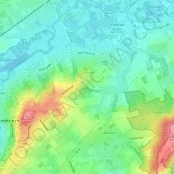
Name: Onkerzele topographic map, elevation, terrain.
Location: Onkerzele, Geraardsbergen, Aalst, Oost-Vlaanderen, België (50.76006 3.87995 50.79753 3.93155)
Average elevation: 125 ft
Minimum elevation: 20 ft
Maximum elevation: 354 ft
Make a donation
Gear up for your next adventure:
As an Amazon Associate, this site earns from qualifying purchases at no extra cost to you.
Other topographic maps
Click on a map to view its topography, its elevation and its terrain.
Denderarm Sluis Geeraardsbergen
België > Oost-Vlaanderen > Aalst > Geraardsbergen
Average elevation: 125 ft
Make a donation
Gear up for your next adventure:
As an Amazon Associate, this site earns from qualifying purchases at no extra cost to you.
Provinciaal Domein "De Gavers"
België > Oost-Vlaanderen > Aalst > Geraardsbergen
Average elevation: 75 ft