Geolocate
👉 Easily get elevation data in JSON, GeoTIFF and KML formats using Elevation API
Thank you for supporting this site ❤️
Make a donation

Consett topographic map

Click on the map to display elevation.

About this map

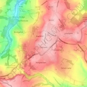
Name: Consett topographic map, elevation, terrain.

Location: Consett, County Durham, North East, England, United Kingdom (54.82807 -1.88241 54.88004 -1.80089)

Average elevation: 673 ft

Minimum elevation: 262 ft

Maximum elevation: 909 ft

Other topographic maps

Click on a map to view its topography, its elevation and its terrain.

Hamsterley

United Kingdom > England > County Durham

Average elevation: 433 ft

Toft Hill

United Kingdom > England > County Durham

Average elevation: 525 ft

New Brancepeth

United Kingdom > England > County Durham

Average elevation: 463 ft

Carrville

United Kingdom > England > County Durham

Average elevation: 246 ft

Gear up for your next adventure:

🔦LED Headlamp - Bright and durable LED headlamp for night navigation
🌐World Map Poster - Decorative world maps with topographic info
🧢Sun Protection Hats - Wide-brimmed and UPF-rated hats for high-altitude sun safety
🌡️Portable Weather Meter - Track weather conditions on the trail
🔦Compact Flashlight - Reliable flashlight for emergencies

As an Amazon Associate, this site earns from qualifying purchases at no extra cost to you.