
Make a donation
Gear up for your next adventure:
As an Amazon Associate, this site earns from qualifying purchases at no extra cost to you.
Porema topographic map
Click on the map to display elevation.
Make a donation
Gear up for your next adventure:
As an Amazon Associate, this site earns from qualifying purchases at no extra cost to you.
About this map
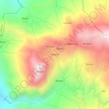
Name: Porema topographic map, elevation, terrain.
Location: Porema, Atsabe, East Timor (-8.91210 125.35755 -8.87210 125.39755)
Average elevation: 2,976 ft
Minimum elevation: 1,263 ft
Maximum elevation: 4,649 ft
Make a donation
Gear up for your next adventure:
As an Amazon Associate, this site earns from qualifying purchases at no extra cost to you.
Other topographic maps
Click on a map to view its topography, its elevation and its terrain.
Atauro
The landscape of the island is a result of the erosion of uplifted, originally submarine, volcanos from the Neogene period creating narrow, dissected ridges and steep slopes. Up to an elevation of about 600 m there are also extensive areas of uplifted coralline limestone. The climate is distinctly seasonal,…
Average elevation: 354 ft