Geolocate

Förbau topographic map

Interactive map

Click on the map to display elevation.

About this map

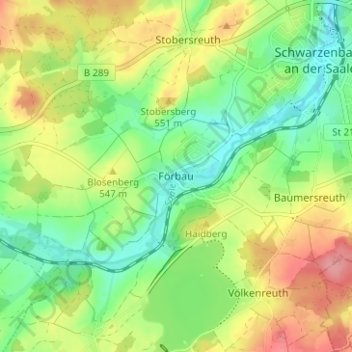
Name: Förbau topographic map, elevation, terrain.

Location: Förbau, Schwarzenbach a.d.Saale, Landkreis Hof, Bayern, 95126, Deutschland (50.18917 11.88756 50.22917 11.92756)

Average elevation: 1,745 ft

Minimum elevation: 1,614 ft

Maximum elevation: 1,926 ft

Other topographic maps

Click on a map to view its topography, its elevation and its terrain.

Martinlamitz

Deutschland > Bayern > Landkreis Hof > Schwarzenbach a.d.Saale

Martinlamitz, Schwarzenbach a.d.Saale, Landkreis Hof, Bayern, 95126, Deutschland

Average elevation: 1,804 ft

Stobersreuth

Deutschland > Bayern > Landkreis Hof > Schwarzenbach a.d.Saale

Stobersreuth, Schwarzenbach a.d.Saale, Landkreis Hof, Bayern, 95126, Deutschland

Average elevation: 1,739 ft

Schwingen

Deutschland > Bayern > Landkreis Hof > Schwarzenbach a.d.Saale

Schwingen, Schwarzenbach a.d.Saale, Landkreis Hof, Bayern, 95126, Deutschland

Average elevation: 1,716 ft

Förmitztalsperre

Deutschland > Bayern > Landkreis Hof > Schwarzenbach a.d.Saale > Völkenreuth

Förmitztalsperre, Völkenreuth, Schwarzenbach a.d.Saale, Landkreis Hof, Bayern, Deutschland

Average elevation: 1,778 ft